The Kimberley
Anyone who has been to the Kimberley will tell you that there is something very special about it - something that cannot be explained, only experienced.
The Kimberley region of Western Australia is the state's northernmost region. The coastline faces the Indian Ocean to the west and the Timor Sea to the north. The region encompasses an area of 421,451 square kilometres (one-sixth of the State's total landmass) and is bordered by the Great Sandy Desert in the south and the Northern Territory in the east.
The Kimberley is almost twice the size of Victoria and three times that of the United Kingdom. The geography of the Kimberley region includes arid desert areas, gorges, sandy beaches, escarpments, rainforests, waterfalls, vast open plains, river valleys and cave systems. The region is remote from major metropolitan areas. Broome is 2,213 km by road from Perth. Kununurra is 3,205 km by road from Perth, 1042 km from Broome, but only 829 km by road from Darwin.
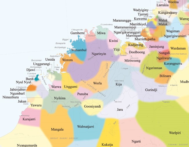
Within the region, there are over 100 Aboriginal communities of various population sizes, speaking over 40 different dialects. A third of the region’s population is Aboriginal or Torres Strait Islander people.

The 2016 Estimated Residential Population (ERP) of the Kimberley is 36,392 which represents 1.4% of the State's population.
Kimberley has a younger population compared to other regions. The age-structure differs from that of the State by having a higher percentage of children aged 0-14 years and people aged 20-44 years, and lower proportion of adults aged 50-74 years and 75 years and over.
The proportion of the Kimberley population aged 50-74 years is 19% (State 25%) while 2% are aged 75 years and over (State 6%).

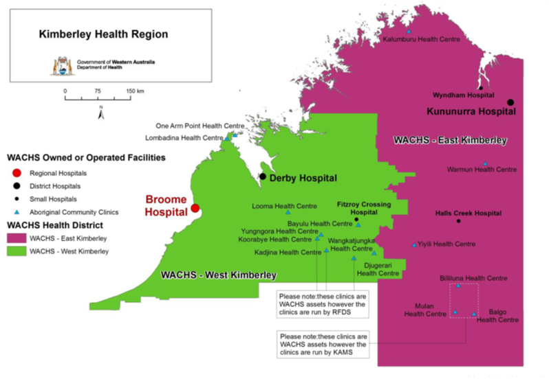
Map of Kimberley showing health districts and WACHS health facilities. WACHS Kimberley Health Profile 2018
The main population centres in the Kimberley region are:
- Broome (estimated population 16,222)
- Derby (estimated population 7,730)
- Fitzroy Crossing (estimated population 1,200
- Halls Creek (estimated population 3,269)
- Kununurra (estimated population 7,500)
- Wyndham (estimated population 900)
Remoteness
According to the Accessibility/Remoteness Index of Australia (ARIA), almost the entire Kimberley region (97%) is classified by the ABS as Very Remote. The other three per cent (areas around Broome and Kununurra) is remote.
Kimberley Weather
The Kimberley has a ‘Wet’ and ‘Dry’ season.
The dry season is from May-October. The weather is warm, dry, low humidity and cooler at night, with largely predictable blue skies, light breezes and average daytime temperatures between 17-30°C.
The wet season is between November-April. The average daily temperatures range from 25-34°C and a high humidity level. January-March, in particular, bring short but heavy bursts of rain, along with regular thunderstorms, risks of cyclones and localised flooding.
Most attractions and events are in their peak between June-August, and this is when accommodation and travel prices are higher and harder to find. It is also when local services are most in need of support to assist with servicing the needs of a much larger visiting population.
Yawuru Seasons
Yawuru people live by six seasons. We read the changing signs in the wangal (winds), the wula (rainfall) and temperature, and the plants and animals, and notice how these come together.
The wattle flowers in Barrgana mean that the salmon and catfish are fat.
When the wattle seeds, the mullet lay their eggs, and when the seeds open up, the eggs have hatched.
Mati Gilbert
Resources
Here are some resources and links you may find useful:
- KAMS – Kimberley Aboriginal Medical Services
- KAHPF – Kimberley Aboriginal Health Planning Forum
- Goolari Media
- IHHP – Indigenous Hip Hop Program
- Australian Indigenous Health Info Net
- WACHS 2018 Kimberley Health Profile
- Yawuru website
- National Rural Health Student Network
- CRANA Plus Bush Support (available 24/7)
- Beyond Blue

Connect with Notre Dame on Social Media
Australia
Fremantle
Broome
Sydney